GeoDataViewer
Menu
Launch Studio
Theme

Shadow Map Online — 3D Building Shadow Simulator

Choose a location, date and local time to see how building shadows change through the day. Easy mode calculates the sun position for the map center. Switch to Advanced for manual shadow controls.

Compare building shadows by date and time

  1. 1. Fix the location. Center the map on the building or street you want to inspect and zoom to level 15 or closer. Check that the required building footprints and heights are available.
  2. 2. Compare times on one date. In Easy mode, select a date and compare morning, midday, and afternoon with the time slider. Read the local clock and detected time zone shown in the controls.
  3. 3. Compare two seasons. Keep the location fixed and select another date at the same local clock time. Sun elevation, daylight duration, and daylight-saving offsets can differ; the tool shows the building-shadow estimate at each selected instant.

Use the preview to explore where nearby buildings may cast shade. Trees, terrain, detailed roof shapes, and missing buildings are not included, so a clear area on the map does not establish total sunlight hours or solar-panel output.

Building shadow map example

Explore how afternoon shadows fall between buildings in New York, then use the interactive map above to compare your own location and time.
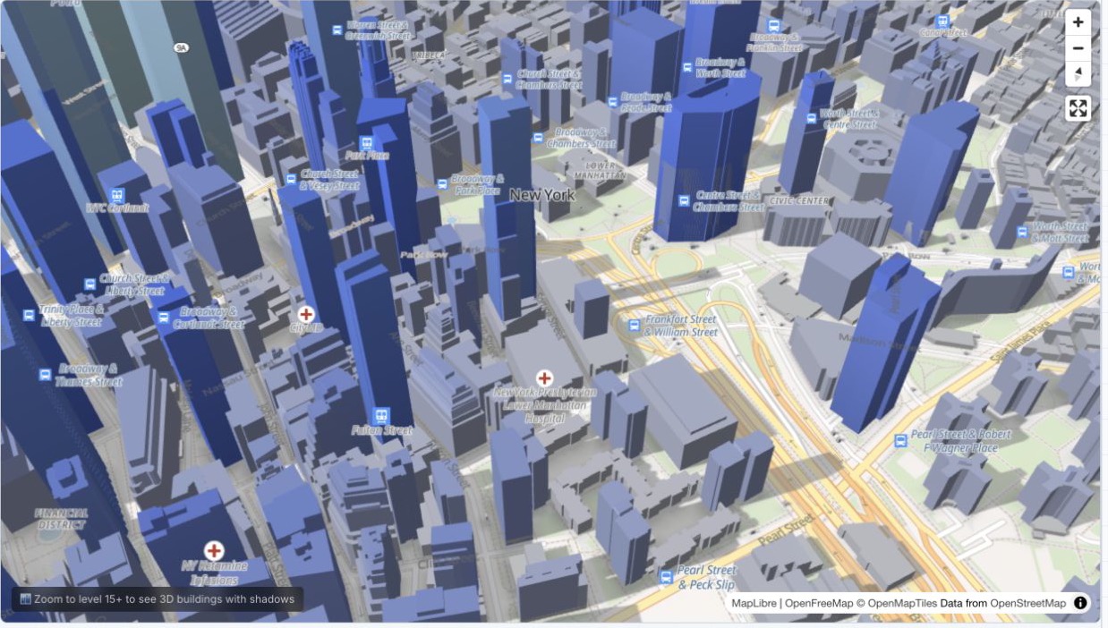
3D building shadow map of Lower Manhattan, New York, showing afternoon shadows across streets and nearby buildings
Lower Manhattan, New York — September 13, 2026 at 15:30 EDT (America/New_York). Actual Easy mode screenshot using available building heights and a flat-ground shadow estimate. Map data: OpenFreeMap, OpenMapTiles and © OpenStreetMap contributors.

What this tool does

Preview building shadows using the date, local time and map location. The estimate depends on available building heights and assumes flat ground.

How to use

Choose a city or pan the map, zoom to level 15+, then select a date and drag the time slider. Use Now to return to the current instant. Collapse the controls for more map space.

Sun direction

Easy mode shows the calculated sun elevation and compass direction. Advanced mode lets you adjust direction independently of the date and time.

Shadow quality

Shadows include a built-in Gaussian blur for soft edges. In Advanced mode, use Blur for softness and Intensity for opacity.

Ambient occlusion

AO adds contact shadows at building bases for a grounded look. Adjust radius (how far the shadow extends) and intensity (how dark it is).

Privacy

Rendering happens in your browser. Map tiles are requested from OpenFreeMap for the visible area.

Frequently Asked Questions

Which time zone does the time slider use?
It uses the time zone at the map center, not your device time zone. Moving to another zone preserves the selected instant and updates the local clock. You can override the detected zone in Time zone settings. Repeated daylight-saving hours can be selected separately.
How accurate are the shadows?
This is an approximate building-shadow preview. It uses available building heights on flat ground and does not include terrain, trees, detailed roofs or buildings outside loaded tiles. Near the horizon, shadow length is capped at 20 times building height. It does not calculate sunlight hours or certify solar access.
Can I calculate shadows for a specific date and time?
Yes. Easy mode calculates the sun position at the map center for your selected date and local time. The time zone is detected from the area, including daylight saving time. Advanced mode keeps the manual direction controls.
Can I compare building shadows in different seasons?
Yes. Keep the map centered on the same location and compare two dates at the same local clock time in Easy mode. Check the detected time zone because daylight saving can change the UTC offset. The preview estimates building shadows; it does not calculate total sunlight hours.
How does the building shadow map work?
Easy mode uses the sun direction and elevation to project the available building heights onto flat ground. Shadows point away from the sun and become longer as it gets lower. Direct shadows are turned off when the sun is below the horizon.
Can I see shadows for any city?
Yes. The map uses OpenMapTiles vector tiles which include 3D building data for most cities worldwide. Pan and zoom to any location, and buildings with shadows will appear at zoom level 15 and above.
What do the Sun Direction X and Y sliders do?
X controls the east-west direction of the sun (negative = west, positive = east). Y controls the north-south direction (negative = south, positive = north). These Advanced controls adjust the appearance manually; use Easy mode for a selected date and time.
What is ambient occlusion (AO)?
Ambient occlusion adds soft contact shadows at the base of buildings where they meet the ground, making them look more grounded and realistic. The AO Radius and Intensity sliders let you control how far and how strong this effect is.
Is my location data stored?
Shadow rendering runs in your browser. The map requests tiles from OpenFreeMap to display the area you are viewing.