Famous Inventions by US State — Infographic Map & Dataset
Quick answer: This dataset turns the supplied famous-inventions infographic into 50 state polygons with 48 readable labels. Virginia and Vermont remain null, and the repeated NJ / Radar callout is documented. Labels reproduce the image and do not establish an invention's origin, inventor or date.
About this dataset
Explore 48 readable state-to-invention labels across 50 polygons, with two missing labels and the image's repeated New Jersey callout documented.
A text map transcribed from “Famous Inventions from Each U.S. State”. It preserves the image's invention, product, company, cultural and landmark labels rather than presenting them as verified invention origins. Virginia and Vermont have no readable labels and retain null values. Two separate NJ / Radar callouts are documented as a duplicate source label; New Jersey appears once in the 50-state dataset. The page draws its own state map with Alaska and Hawaii insets and text labels, without reproducing the source illustrations or logos. Labels are transcribed from a user-supplied infographic and have not been independently verified. The original image's publisher, publication date and content license are unknown. A source attribution or year printed in the image does not verify its selections or methodology.
Data source: User-supplied infographic transcription (unverified)
Attribution: Labels are transcribed from a user-supplied infographic and have not been independently verified. The original image's publisher, publication date and content license are unknown. A source attribution or year printed in the image does not verify its selections or methodology. The image supplies no source attribution. Boundaries: US Census Bureau MAF/TIGER (2018), via geoBoundaries, simplified by GeoDataViewer. Transcribed 2026-10-22; this is not the source publication date.
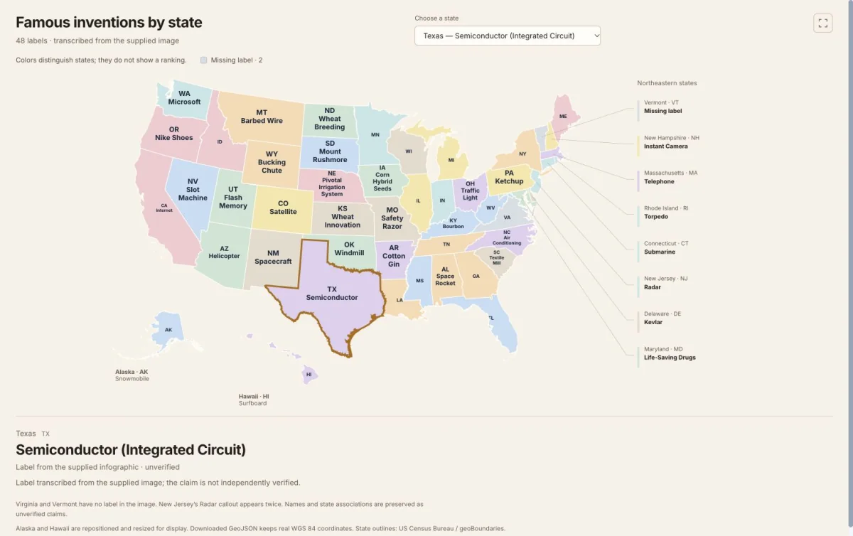
Actual dataset map screenshot. 48 readable invention-themed labels; Virginia and Vermont remain missing. Labels transcribed from a supplied infographic; original artwork is not reused. State outlines: US Census Bureau / geoBoundaries. Captured 22 October 2026.
All 50 state records — invention-themed label
Labels reproduce the supplied image. Missing labels remain empty in the downloadable files.
| State | Code | Invention-themed label | Transcription status | Notes |
|---|---|---|---|---|
| Alaska | AK | Snowmobile | Transcribed | — |
| Alabama | AL | Space Rocket (Saturn V) | Transcribed | — |
| Arkansas | AR | Cotton Gin | Transcribed | — |
| Arizona | AZ | Helicopter | Transcribed | — |
| California | CA | Internet (Modern Web) | Transcribed | — |
| Colorado | CO | Satellite | Transcribed | — |
| Connecticut | CT | Submarine | Transcribed | — |
| Delaware | DE | Kevlar® | Transcribed | — |
| Florida | FL | GPS Technology | Transcribed | — |
| Georgia | GA | Peach Cultivation (Modern Variety) | Transcribed | — |
| Hawaii | HI | Surfboard | Transcribed | — |
| Iowa | IA | Corn Hybrid Seeds | Transcribed | — |
| Idaho | ID | Potato Harvester | Transcribed | — |
| Illinois | IL | Skyscraper | Transcribed | — |
| Indiana | IN | Airplane | Transcribed | — |
| Kansas | KS | Wheat Innovation (Hardy Wheat) | Transcribed | — |
| Kentucky | KY | Bourbon | Transcribed | — |
| Louisiana | LA | Zydeco Music (Influential Music Tech) | Transcribed | — |
| Massachusetts | MA | Telephone | Transcribed | — |
| Maryland | MD | Life-Saving Drugs (Penicillin) | Transcribed | — |
| Maine | ME | Lobster Trap | Transcribed | — |
| Michigan | MI | Automobile | Transcribed | — |
| Minnesota | MN | Pacemaker | Transcribed | — |
| Missouri | MO | Safety Razor | Transcribed | — |
| Mississippi | MS | Motion Pictures (Cinematograph) | Transcribed | — |
| Montana | MT | Barbed Wire | Transcribed | — |
| North Carolina | NC | Air Conditioning (Modern System) | Transcribed | — |
| North Dakota | ND | Wheat Breeding | Transcribed | — |
| Nebraska | NE | Pivotal Irrigation System | Transcribed | — |
| New Hampshire | NH | Instant Camera | Transcribed | — |
| New Jersey | NJ | Radar | Transcribed | Two separate NJ / Radar callouts appear in the image; the repetition is recorded in duplicateLabels. |
| New Mexico | NM | Spacecraft | Transcribed | — |
| Nevada | NV | Slot Machine | Transcribed | — |
| New York | NY | Credit Card | Transcribed | — |
| Ohio | OH | Traffic Light | Transcribed | — |
| Oklahoma | OK | Windmill | Transcribed | — |
| Oregon | OR | Nike Shoes | Transcribed | — |
| Pennsylvania | PA | Ketchup | Transcribed | — |
| Rhode Island | RI | Torpedo | Transcribed | — |
| South Carolina | SC | Textile Mill | Transcribed | — |
| South Dakota | SD | Mount Rushmore | Transcribed | — |
| Tennessee | TN | Electric Guitar | Transcribed | — |
| Texas | TX | Semiconductor (Integrated Circuit) | Transcribed | — |
| Utah | UT | Flash Memory | Transcribed | — |
| Virginia | VA | No readable label | No readable label | No readable invention callout is visible for Virginia in the supplied image. |
| Vermont | VT | No readable label | No readable label | No readable invention callout is visible for Vermont in the supplied image. |
| Washington | WA | Microsoft | Transcribed | — |
| Wisconsin | WI | Typewriter | Transcribed | — |
| West Virginia | WV | Coal Mining Methods | Transcribed | — |
| Wyoming | WY | Bucking Chute | Transcribed | — |
Transcribed means the label was readable in the image; it does not mean the claim was independently verified.
How to download
- 1 Click a state or use the state selector to read the full label and transcription notes.
- 2 Review the complete 50-state table, including missing labels and any source discrepancies.
- 3 Download GeoJSON for a polygon layer, or CSV for attributes joined using state_code or shapeISO.
- 4 Check the original claims against independent sources before using the labels as factual rankings or historical evidence.
FAQ
Are these verified inventions originating in each state?
No. The image supplies no publisher, date or sources. Some labels describe companies, products, cultural forms or landmarks rather than inventions. Every readable label is preserved as an unverified image claim, without asserting an inventor, first occurrence or place of invention.
Which state labels are missing?
Virginia and Vermont have no readable invention labels in the supplied image. Their label and raw_label values are null and their status is missing_label. No historical association was guessed to fill those gaps.
Why does New Jersey appear only once?
The original image has two separate boxes labeled NJ / Radar. The dataset contains one New Jersey polygon and one Radar label, with the repeated callout recorded in the source notes and duplicateLabels GeoJSON metadata. The extra box is not reassigned to a different state.
Are the original invention illustrations included?
No. The preview uses text on separately drawn state polygons. The downloaded files contain geometry, labels and provenance fields, without the supplied image's illustrations, trademarks or logos as artwork.
Can I use these files in GIS software?
The GeoJSON contains 50 state polygons in WGS 84, with original labels, label_status, verification and source notes. The CSV contains the same attributes without geometry; join it using state_code or shapeISO. Alaska and Hawaii are repositioned only in the page's SVG preview. The downloaded geometry retains real coordinates. Boundary geometry is public domain; the supplied infographic's label license is unspecified, and its artwork is not included.