Puerto Rico ZCTA Boundaries + ACS Demographics
Quick answer: Download 132 Puerto Rico ZCTA polygons joined to 2020–2024 ACS estimates and margins of error. The boundary vintage is 2020, the statistical period is 2020–2024, and coverage is Puerto Rico only.
Download, inspect and select Census records
- 1.Choose a bundled GeoJSON or CSV below. GEOID and ZCTA codes are text; preserve leading zeros.
- 2.Use the radius tool for ZCTA representative points, or filter vector attributes and select features before exporting. A point-in-radius result does not mean the entire ZCTA polygon is inside.
- 3.ACS files contain 2020–2024 five-year estimates and 90% margins of error. Read field notes and join diagnostics; missing or special values are not zero. Bundled ZCTA polygons cover Puerto Rico only.
About this dataset
132 real Puerto Rico ZCTA polygons with 2020–2024 ACS estimates/MOEs, ready to download and use in spatial tools.
A compact, usable polygon package covering Puerto Rico ZCTAs 006xx, 007xx and 009xx. The official 2020 Census cartographic boundaries are joined to the official 2020–2024 ACS population, income, age and housing tables. This is explicitly a Puerto Rico subset, not a national ZCTA boundary file. Further web-map simplification uses 0.001° tolerance; the original national shapefile is linked for precise work.
Data source: U.S. Census Bureau
Attribution: U.S. Census Bureau: 2024 Gazetteer; 2020 and 2024 Cartographic Boundary Files; 2020–2024 American Community Survey 5-year Detailed Tables B01003, B19013, B01002, B25001. Prepared by GeoDataViewer. Source estimates and special codes retained; cartographic outlines generalized for web display. Public domain — U.S. Census Bureau public data
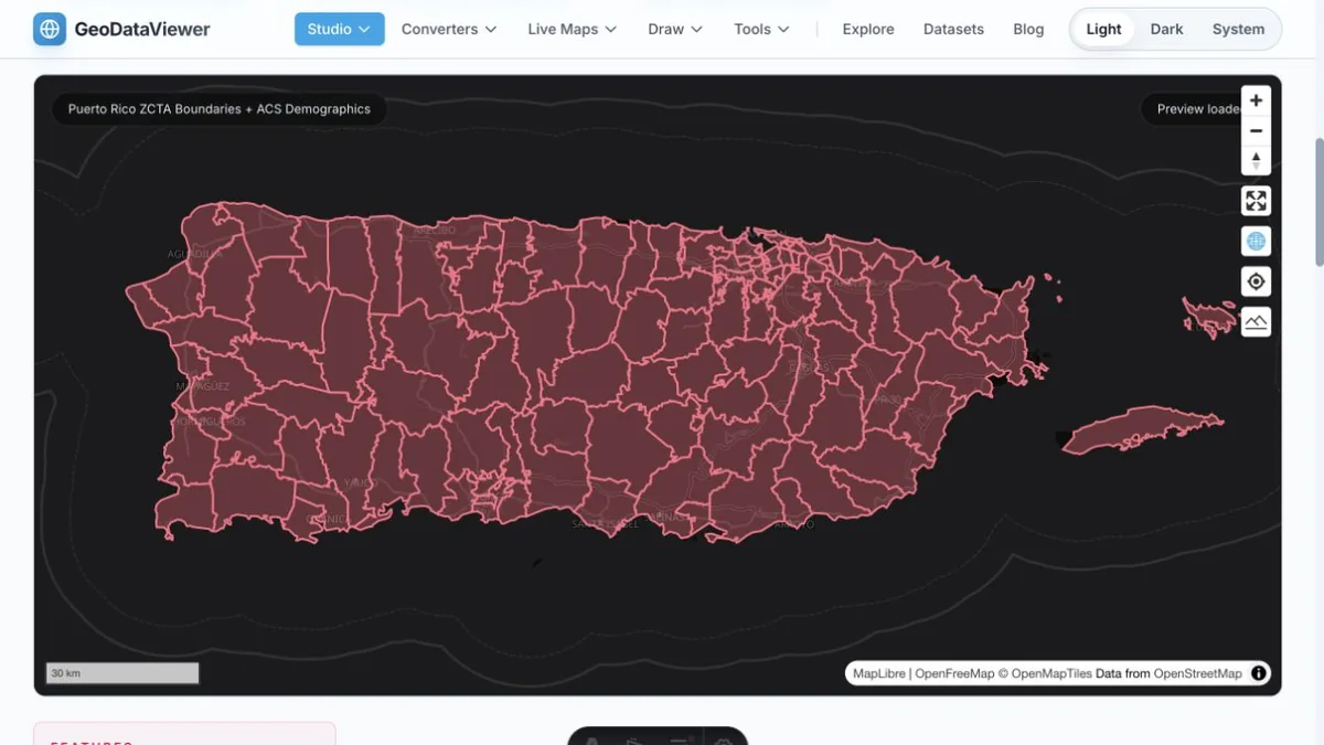
Actual bundled Census data on the map; map and basemap credits shown. Captured 24 October 2026.
How to download
- 1 Read the coverage, survey period and ZIP/ZCTA definitions below.
- 2 Download GeoJSON to view in Studio or continue in a tool; choose CSV for a table join and import identifiers as text.
- 3 Keep the published estimate and its margin of error together; null observations are not zero.
- 4 Retain the U.S. Census Bureau citation and provenance when sharing derivatives.
Puerto Rico ZCTA GeoJSON — 132 polygons (248 KB)
Source rights and citation
Census public data policy and attribution
Field definitions
Types, units, exact ACS source variables and missing-value interpretation
Provenance and checksums
Exact official source URLs, build timestamp, output checksums and join coverage
Join diagnostics
Every unmatched source geography, without inferred or fabricated observations
README and reuse notes
ZIP/ZCTA distinction, coverage, coordinate/simplification limits and attribution
Full national 2020 ZCTA cartographic shapefile
Official external national file; this bundled package covers Puerto Rico only
FAQ
Are ZIP codes and ZCTAs the same?
No. USPS ZIP codes describe mail delivery routes and addresses. Census ZIP Code Tabulation Areas approximate ZIP-code areas for statistical mapping. Not every ZIP has a ZCTA; these packages are not a complete or current USPS ZIP directory. A ZCTA can cross state or county boundaries.
How do I preserve leading zeros?
GEOID and zcta are five-character strings, for example 00601. GeoJSON preserves that type. Import CSV identifier columns as text in Excel or other spreadsheets; do not join numeric IDs or guess a state from a ZCTA prefix.
Are these 2024 population counts?
These are ACS 5-year estimates for the combined 2020–2024 survey period, not a decennial census count, a single-year 2024 measurement or a current population estimate.
What do null values and MOE fields mean?
Every estimate retains its published 90% confidence margin of error in a separate _moe field. Negative Census special-value codes and blanks become null, not zero; original special codes remain in acs_special_values. Controlled estimates can have unavailable MOEs. See fields.json and the source documentation before comparison.
Can I add or average the median values?
No. Averaging county or ZCTA median incomes/ages, even with population weights, does not produce the median for a combined region. Income values are in 2024 inflation-adjusted US dollars. Use appropriate microdata or distribution tables for combined medians.
Is this national coverage?
No. The bundled polygons cover only 132 Puerto Rico ZCTAs (006xx/007xx/009xx). Nationwide points and demographic tables are separate packages; the full official national polygon shapefile is linked for download.